


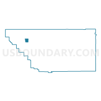
Voting District 40175, Kern County, California
About
Outline

Summary
| Unique Area Identifier | 531802 |
| Name | Voting District 40175 |
| County | Kern County |
| State | California |
| Area (square miles) | 22.55 |
| Land Area (square miles) | 22.55 |
| Water Area (square miles) | 0.00 |
| % of Land Area | 100.00 |
| % of Water Area | 0.00 |
| Latitude of the Internal Point | 35.53676060 |
| Longtitude of the Internal Point | -119.58661190 |
Maps


Graphs
Select a template below for downloading or customizing gragh for Voting District 40175, Kern County, California


Neighbors
Neighoring Voting District (by Name) Neighboring Voting District on the Map
- Voting District 40000, Kern County, CA
- Voting District 40030, Kern County, CA
- Voting District 40055, Kern County, CA
- Voting District 40060, Kern County, CA
- Voting District 40065, Kern County, CA
- Voting District 40085, Kern County, CA
- Voting District 40090, Kern County, CA
- Voting District 40105, Kern County, CA
- Voting District 40215, Kern County, CA
Top 10 Neighboring County Subdivision (by Population) Neighboring County Subdivision on the Map
Top 10 Neighboring Elementary School District (by Population) Neighboring Elementary School District on the Map
- Wasco Union Elementary School District, CA (26,302)
- Lost Hills Union Elementary School District, CA (2,747)
- Buttonwillow Union Elementary School District, CA (2,134)
- Maple Elementary School District, CA (535)
- Semitropic Elementary School District, CA (350)
- Belridge Elementary School District, CA (119)
Top 10 Neighboring Secondary School District (by Population) Neighboring Secondary School District on the Map
- Kern Union High School District, CA (596,351)
- Wasco Union High School District, CA (29,934)
- Taft Union High School District, CA (20,160)